Nice post from James Fee on software agnosticism….. and yes, we all too regularly build an ArcGIS script to find it no longer works in a new version or hasn’t been updated by a third party. And yes, the answer is don’t use them!!! However as I am also doing (some work with Niels Anders), move to Python and do you geospatial processing there, then call from within ArcGIS. You even have Portable Python so no excuse for being tied to a workstation.
Monday, February 18, 2013
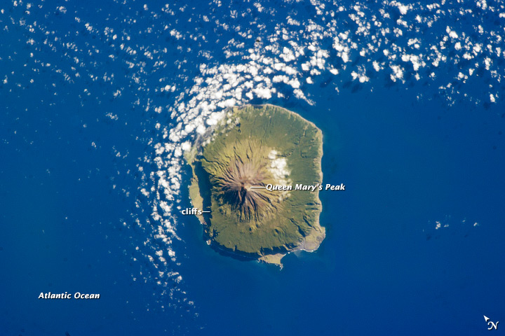
Tristan da Cunha
Great astronaut photo of Tristan da Cunha. Nearest neighbour? St Helena, 2,730 km away! More at Wikipedia.
Sunday, February 17, 2013
Uninstalling apps from your Android ROM
Sick and tired of the crap and bloatware that invades the version of Android on your phone but can’t remove they because they are built in to the ROM? this may be the ROM that shipped with your phone or one that you installed, but with budget phones shipping with budget amounts of memory every MB counts.
So I got to the point with my San FranII where I needed to free up space and didn’t use bloatware like YouTube, Mail (replaced with k9mail) and even Google Maps (MapDroyd). How to get rid of them? Well, first and foremost your phone needs to be rooted…. then it’s a case of finding an app that will do what it says on the tin. After a few false starts I stumbled across Root App Delete which just works.
Root App Delete allows you to identify all user and system installed apps…these can be disabled which moves them to the recycle bin. They are still there but inactive…..this is slightly counterintuitive, but actually very helpful because once gone…they really are and you don’t want to go removing something central to the OS (like the launcher!). If you are dead sure you want to get rid of it, uninstall from the recycle bin and “ta da”, it’s gone freeing up valuable space in memory.
Friday, February 15, 2013
Get some Oomf(o) in your presentations…..
Have you ever been watching a TED talk and wondered how they got that cool dynamic chart? Did someone slave for hours over a long Flash animation? Well, I can’t vouch for other speakers, but Oomfo, which is in a Google-esque long-term beta, provides such an option. It’s an add-in for Powerpoint that allows you to dump data in to the presentation and produce animated/dynamic charts, depending on the data type. This could be as simple as a rather stylish histogram with bars that grow, interactive pie charts that you can get dynamic labels/rotate/resize, fully interactive 3D plots or an infinite x-axis which is fully scrollable. The effects are excellent and, as ever, its not about the design replacing the content, but augmenting it and adding elements the surprise and delight, whilst reinforcing your message.
Try it!