NDVI Differencing
During my remote sensing class in the fall term I cover some introductory level image processing techniques that can be used in quite profound ways. If we have a multi-spectral image with each layer imaging the Earth at different wavelengths, how can we manipulate that? Well, one very common technique is a ratio (divide one wavelength by another), giving you the proportion of variation of one layer relative to another. Where this is powerful is when you have two diagnostic wavelengths unique to your surface of interest (e.g. green and red), with very large differences in reflectance. This allows you identify very subtle variations in your target wavelengths. For vegetation, green and NIR are ideal wavelengths and the Ratio Vegetation Index does this. However its not comparable to other RVI measurements (and can vary to infinity), so its common to normalise (i.e. look at the range rather than absolute values) this calculation, a measurement called the Normalised Difference Vegetation Index. This gives you the amount of “greenness” and is calculated operationally as a product for many satellites. Its powerful for monitoring vegetation and is used extensively for things like crop-management and deforestation.
On their own, many of these techniques offer significant insights about the environment. However in combination, they allow you to perform complex tasks and create greater understanding. Another common process is to subtract two images at different time periods allowing you see the change that has occurred; very effective for temporal analysis. And, of course, when combined with the NDVI you get to see change in vegetation through time.
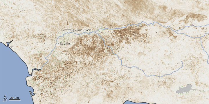
What kicked this blog entry off was a really good NASA Image of the Day which shows the dramatic effect of drought and decreasing vegetation in Spain. For robustness the NDVI average over a 16-day period this spring is taken and then subtracted from the overall average. Using the data the USDA have been able to estimate the yield and therefore the shortfall in harvest against need and so the approximate requirement for import. For me, it is this simple work that shows the importance of operational remote sensing at an international, national, regional and even individual level. It affects everyone.