Initial TopSat Data
 As part of the availability of TopSat tasking to UK higher education, we had our initial request for three sites in Armenia approved and have just taken delivery of the first of these. Whilst the conditions were not ideal due to the presence of a large amount of snow at higher elevations, the 2.9m panchromatic and 5.7m RGB should be ideal for our use; namely acquiring ground control for classifying DMC data of Armenia. So other issues aside, when you zoom in on the data, as the screenshot shows, there are horrible block artefacts in the imagery. Whilst we have asked why this is, my guess is that this is lossy image compression, possibly applied at the satellite prior to download. At present it remains unfit for purpose (because I can’t actually see any trees even at 2.9m resolution!). Watch this space.
ArcMap Geometry
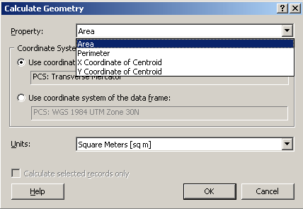
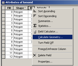 One of the “exciting new features” in ArcMap 9.2 is vector geomtry. What hifalutin new feature is this I hear you cry? What spatial treats has ESRI unleashed upon us? Well, have a look at the graphic (right) to see a new menu item (Calculate Geometry) that is available in the attribute table. If you select that you will be presented (dependent upon whether you have a point, line or poly layer) with the following dialogue box (below). And, excitement upon excitement, those of us not blessed with extensive VBA skills can now find out the location of our feature (or its length or perimeter and area).
OK, so I had a rant about this a little while ago and it’s nice to see it in the final product….
Peyton and Byrne @ St “Meet me at” Pancras
I met a colleague at St Pancras recently and we decided to grab a quick coffee so headed to the nearest coffee bar which happened to be Peyton and Byrne, “a British Bakery”. All I can say is that if this is the state of British bakeries, please o please bring on the French. A luke warm cup of coffee, followed by a rock hard sandwich for my colleague was enough. And to cap it all off, someone walked off with my cuppa leaving a half-finished hot chocolate. Cheers!
Open Peer Review
At the Journal of Maps we operate an open peer-review system when reviewing papers that have been submitted. Peer-review has been around for over 300 years and, as far as the academic commumnity is concerned, is the best method to review the quality of material for publication. That is not to say it is ideal because it is far from it, but a viable alternative remains to be found. Of course peer-review is simply a “quality check” on an individual’s work by their peers and with such a simple definition there is scope for a myriad of operational systems. In practice the primary concern comes down to whether the authors and/or reviewers remain anonymous. These are term single-blind and double-blind systems and the reasoning is that anonymity increases the likelihood of an unbiased review. This of course is a mute point and there have been a number of studies that looked at how these systems can be abused. This occurs in the form of “gift authorship” (where authorship is given to a minor party), redundant publication (multiple publication of principally the same work), but also covers plagiarism and deliberate delay (by referees). Whilst it is usually hard to retain author anonymity because of relatively small research communities, it is much easier to remain anonymous as a reviewer. This promotes the “pot shot” culture where a manuscript is an easy target for critcism. This is not good and most authors are familiar with the crushing feeling that an abusive review manifests. JoM therefore operates an open peer-review system where neither author or reviewer remains anonymous. We believe that reviewers are responsible for their comments and should be able to stand by them. Whilst the general principle is sound, this is open to subtle abuse. For example, a reviewer of a manuscript from a “well known” author might be reluctant to be overtly critical regardless of the quality of the manuscript. I know of colleagues who, whilst being the most appropriate reviewers, have refused on the grounds that it might not be the best career choice!It is notable that there are general “norms” for peer-review across disciplines, with spatial subjects (geography, geology) being quite conservative. Single and double blind systems are common and there is a certain amount of the “pot shot” culture (although any good editor will mitigate against this). Other subjects are much more liberal in their reviewing methods. This can include the public posting of a manuscript for comment and revision by any interested parties, prior to publication. This opens up the opportunity for significant contribution by other researchers and, in certain circumstances, it is appropriate for co-authorship to be offered. Indeed, peer-review offers the opportunity for significant “value added” through the improvement of a manuscript. I believe at JoM that nearly all maps have seen improvement as a result of review, with a small proportion significantly improved. It would be nice to think that in these instances joint-authorship might be a consideration.
Standard Normal Transform
Following on from the previous post on animating a stem and leaf plot for teaching, here is another one on a standard normal transforms.